


GIS Surveyor - Land Survey and app
free GIS Surveyor - Land Survey and app
download GIS Surveyor - Land Survey and app
GIS Surveyor - Land Survey and apk
free GIS Surveyor - Land Survey and apk
download GIS Surveyor - Land Survey and apk

GIS Surveyor - Land Survey and
2.0


100K+


Name
GIS Surveyor - Land Survey and

Developer
PoloSoftech

Price
Free

Updated on
2023-10-19

Category
Maps & Navigation

Version
2.10


About This app
The application comes on a subscription basis. You will be charged only after 3 days of free trial. Also, we would really appreciate if you reach us with your issues before rating us.
To raise a ticket, find a link below ↓↓
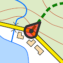
GIS Surveyor is a GIS application meant for GIS survey, GIS Data handling, data collection, analysis, and planning before execution of a project. It allows professional surveyors with an opportunity to collect more accurate survey data in a stipulated time frame. This application is also a GIS remote sensing application that can be used for GIS Mapping.
GIS Surveyor is a GPS/GNSS based survey application that uses GPS data collection. It will be used for various types of environmental surveys and field surveys while also enabling the GIS data collection to be faster and efficient.
This application can be used for Field Survey,Land Survey,and other surveys which includes field data collection including internal GPS or external GPS.
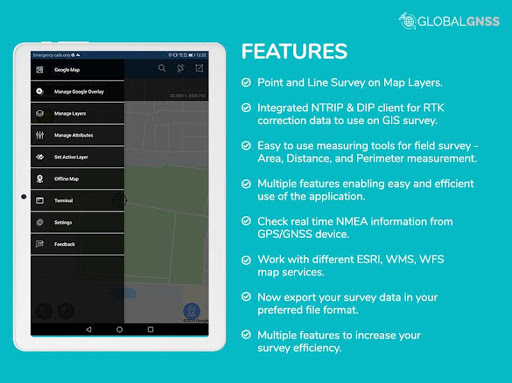
-Top GIS Survey Application features:
- GIS data collector
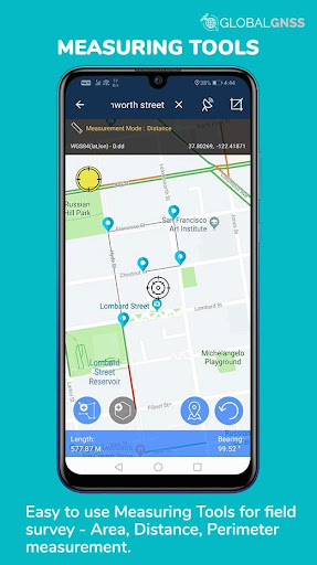
- Calculate the area and distance.
- GPS land area calculator
- Attributes can be imported from any other project or device.
- Survey using images for any location is available, with multiple export options.
- One set of attributes can be used across multiple surveys.
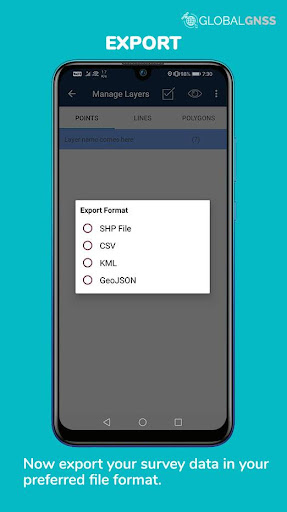
- Various Export file formats for GIS data are CSV, KML, and GeoJSON.
- Post process of data can be performed with software like ArcGIS, ArcGIS online or qGIS.
- With external Bluetooth GPS/GNSS device connected, NTRIP/RTK data can be utilised for accuracy.
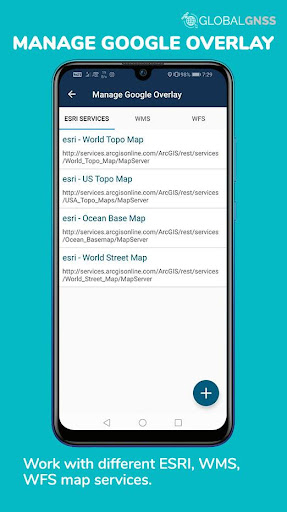
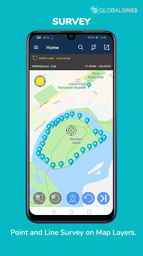
- Survey on online gis maps, and GIS offline maps(supports mbtiles)
- WMS and WFS Surveyor tiled maps are supported, load topographic and orthophoto maps, geological surveys, cadastral information.
- Currently 4 methods of data collections are supported, GPS / GNSS location, map cursor location,GIS Tracker, point projection using angle and distance.
-Mapit GIS survey on multiple kinds of GIS maps.
- Direct export to Dropbox,Google Drive, FTP location.
- Import point, line and polygon layer in CSV, KML or geojson file.
- Possibility to view multiple layers including points, lines and polygons at the same time.
- Possibility to group the data into survey layers - each survey layer may have a default set of attributes.
- Create new polygon or line features and measure details like area, length and perimeter.
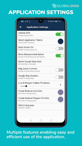
- Backup management.
- Export in .SHP format .
- Export in GPX format..
- Works with GEOID Model to provide elevation for a point.
- Recieve Mock Location from 3rd party application.
- Coordinate System Geoid EGM96
Industries that our survey application caters to:
- Forestry and Timber inventories.
- Residential Land, Commercial Land, and Government Land.
- GPS surveying and GNSS survey.
- Land Survey.
- Agricultural and Farm Survey.
- Field Surveys.
- Environmental Systems.
- Highway Road surveys.
Supports Android OS 4.4 and above
This application is made ads-free and hence it will increase your productivity. If you have any problems in installing or downloading or if you face any kind of issue with the application functionalities kindly raise a ticket at: http://globalgnss.com/support/
Visit us at www.globalgnss.com.
Show More
Screenshots


Comment
Similar Apps


Similar Apps


Top Downloads


Copy [email protected]. All Rights Reserved
Google Play™ is a Trademark of Google Inc.
ApkYes is not affiliated with Google, Android OEMs or Android application developers in any way.

