


Superior Hiking Trail Data Map app
free Superior Hiking Trail Data Map app
download Superior Hiking Trail Data Map app
Superior Hiking Trail Data Map apk
free Superior Hiking Trail Data Map apk
download Superior Hiking Trail Data Map apk
Superior Hiking Trail Data Map
3.8


1K+


Name
Superior Hiking Trail Data Map

Developer
GeoPOI LLC

Price
Free

Updated on
2018-05-13

Category
Maps & Navigation

Version
1.0.1


About This app
Safely hike the trail with a robust data app that contains no ads, in-app purchases, or social media connections. Truly free and open-source! We wanted to provide a robust offline-capable map and guide for the Superior Hiking Trail that hikers can use as a backup source of navigation. It is not meant to be a substitute for a paper map, compass, and data book, but rather a supplement.
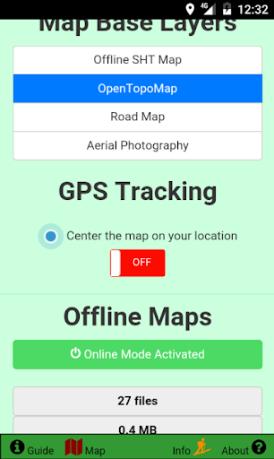
Inside the app there are five tabs including the interactive map, a guide for the map controls, a pane for adjusting map settings, an information tab containing a wealth of relevant facts, tips, and resources, and finally a page summarizing all of the great projects utilized in the app.
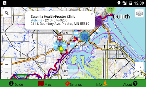
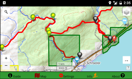
The map is the centerpiece of the app. It is designed to work in offline mode and consume a minimal amount of battery. A basic map loads by default, but this can be changed in the Map Settings tab to one of three other basemaps - a topo map, a road map, and satellite imagery. Desired sections of these layers can be downloaded in advance and used offline for areas where reception is limited.
The map is also integrated with your phone's GPS so you can track your position on the map, even while in airplane mode! Leaving this feature and your GPS on will quickly drain your phone's battery, so we recommend that you use this only when needed.
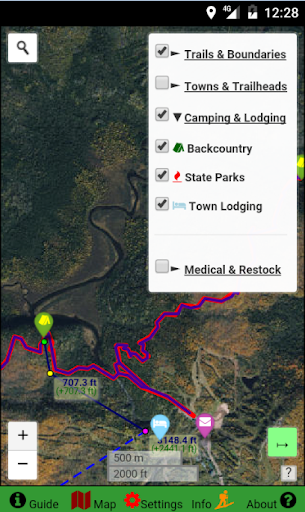
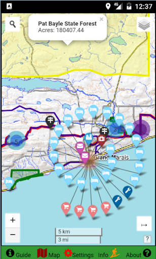
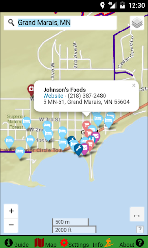
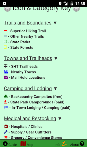
Several useful overlay layers can be toggled to allow users to create their own custom map. These layers include trail line tracks, State Park and Forest boundaries, and the locations of trailheads, campsites, lodging, grocery stores, medical services, towns, and gear outfitters.
Each of these overlay objects reveals a popup when tapped that provides more information and details about the feature. The color and icons of the features also distinguish the category that the feature belongs to and are summarized in a legend.
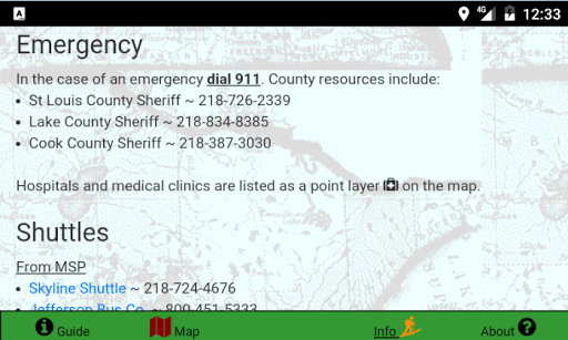
In addition to an informative interactive map, this map also contains a great deal of information about the Superior Hiking Trail and backpacking. This data has been compiled from many sources and formatted to be easily referenced. Some of the areas covered are general SHT and backpacking information, camping and parking regulations and details, emergency contacts, shuttle services along the trail, and information about the mail drop system.
Finally, there is a page dedicated to the many open-source projects utilized in this app. It includes the projects and resources used. On this page there is also a way to send comments or corrections for the app, in case you have addition data you would like to see included in future updates!
A great deal of time and effort has gone in to making this the best Superior Hiking Trail app available! If you enjoy the app or find it useful, give us a good rating and review!
This app will always be free, open-source, and without advertisements. Providing a comprehensive app that will help hikers be safer is more important to GeoPOI LLC than getting rich off of annoying and intrusive ads. If you enjoy this app, please consider donating and supporting more similar apps in the future!
This app requires a few special permissions in order to allow a complete user experience. These features include access to the internet to view and download map tiles, storage write and delete permissions to manage downloaded tiles, and GPS geolocation so that you can locate yourself on the map. All of these features are optional and you can choose whether or not to use them. The app will work in airplane mode.
Thanks for trying the Superior Hiking Trail Data Map, and stay tuned for more similar apps in the future! Safe and happy hiking!!
Show More
Screenshots
Comment
Similar Apps


Similar Apps


Top Downloads


Copy [email protected]. All Rights Reserved
Google Play™ is a Trademark of Google Inc.
ApkYes is not affiliated with Google, Android OEMs or Android application developers in any way.

